Skip

EXHIBITORS & PRODUCTS

Magic Lane

Fleet Management for Cargo bikes

Fleet Management for Cargo bikes

Description

Fleet management & LogisticsStreamlined fleet, smarter routes

Effortlessly plan routes for diverse vehicles, from long hauls to city cargo bikes. Our preprogrammed navigation app ensures safe, efficient deliveries—optimized down to the last mile with cutting-edge map data.

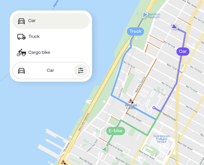
Advanced fleet navigation for efficient multi-stop deliveriesMulti-stop route planning

Easily plan complex, multi-stop delivery routes to streamline operations and reduce travel time.

Multi-modal route optimization

Optimize routes for various vehicle types, from trucks for long hauls to cargo bikes for urban deliveries.

Driver/rider navigation

Preprogrammed navigation for safe and efficient deliveries, tailored for drivers and riders.

Last mile delivery optimization

Maximize efficiency in the final stretch with map data and micromobility solutions for precise delivery.

Additional featuresDistance matrix

Use the Distance Matrix API to find the most efficient routes between multiple origins and destinations, saving time and resources.

Fleet optimization

Enable faster and more efficient deliveries with fewer vehicles, helping your business deliver more with less.

ETA tracking

Calculate precise arrival times for each package, down to the minute, keeping your deliveries accurate and customers informed.

Geocoding

Ensure accurate delivery locations, whether it`s a precise address or a dropped pin on the map.

More products by Magic Lane

Maps & 3D scene

Maps & 3D sceneExperience maps in stunning 3D

Immersive 3D maps bring routes and adventures to life, letting users explore terrain, cities, and destinations like never before.

Craft beautiful routes for every adventureImmersive 3D mapping

Visualize landscapes, trails, and routes in dynamic 3D, offering an elevated perspective for planning and navigating outdoor adventures.

Tailored map layers

Adjust perspectives and explore detailed layers that bring out key features like elevation, landmarks, and difficulty levels—all at a glance.

Customize every detail

Configure map views with a variety of themes, enabling tailored solutions for different use cases and environments.

BasicNightBike firstSatelliteTerrainSmart route calculationReal-time data and updates

Access live weather, terrain, and traffic data to optimize routing and ensure a smooth user experience.

Advanced route planning

Easily tailor routes based on terrain, fitness level, or activity, with AI optimizing the best paths.

Always on. Even offline.

Our lightweight technology lets you download maps and 3D scenes for offline use, ensuring navigation in remote or disconnected areas.

100% surveillance freeDesigned for privacy, securing data and location at every stepAdditional featuresFitness tracking integration

Seamlessly sync with fitness devices and apps to track performance, analyze stats, and monitor progress over time.

Community & sharing

Connect with a global community, share routes and achievements, and join challenges for extra motivation.

Push notifications

Get real-time updates on route changes, safety alerts, and friend activity on the routes you follow.

Heatmaps

Explore popular routes with heatmaps powered by community activity data.

Geotagged photos & videos

Capture moments with automatic location tagging to showcase every adventure.

Elevation profiles

See detailed elevation changes along your route to prepare for climbs and descents with ease.

E-bike companion app

E-Bike companion appPrecision technology for seamless E-rides

The e-bike industry is accelerating, and so is the need for technology made just for bikes. No car-focused features, only what e-bikers need to get where they want to go.

Tailored features for every cyclistCycling-optimized maps and navigation

Designed for cyclists, not cars. Navigate with maps that prioritize bike paths, trails, and safe cycling routes.

Multi-bike type routes

Get tailored routes for every type of bike. Whether you’re on a mountain bike, city bike, or speed pedelec, enjoy a route built for your ride.

E-Bike range calculation

See exactly how far you can go with accurate range estimates based on your e-bike’s battery level.

Weather-optimized routing

Route planning that adapts to real-time weather, factoring in wind, rain, and air quality for safer, smoother rides.

Draw-on-map functionality

Sketch your own route or destination right on the map and follow it effortlessly.

Additional featuresBike tracking

Add theft prevention and fleet tracking capabilities with integrated bike tracking.

Send routes to bike

Seamlessly send routes to embedded bike navigation systems.

Fitness tracking integration

Enable performance tracking and compatibility with top fitness applications.

Air quality and safety

Incorporate real-time air quality and safety info into routing.

Heatmaps

Highlight high-traffic areas with data-driven heatmaps.

Import GPX files

Allow easy import of GPX files for a unified user experience.

Why choose us?Easy, seamless integration100% surveillance freePrivacy and trust are the foundation of everything we build.Always on. Even offline.

Enable seamless navigation, without the need for an internet connection.

Light and flexible integration

Effortlessly implement our technology into any platform to start building instantly.